Earlier in March, when we had a rare sunny and slightly warmer day, I got it in my head that I really wanted to go to Cochrans Falls. Like I couldn't stop thinking about it. It was mind boggling to me that there was a 600 foot waterfall right next to Amicalola State Park that was undeveloped, lightly traveled, and tricky to reach. And only a 45 minute drive from my house. So I read up about it as much as I could online, studied some maps, and we hopped in the car. The general area of the falls is located just north of Highway 52 and there are houses and farms nearby, so I figured it would not be hard to find the trailhead. Wrong! This is a very grey area of gravel roads, private property, public property, dirt driveways, and very little signage.
I followed some incredibly detailed directions, found here, but then we drove across a creek, which was not mentioned in the directions, and that threw me off. I figured we had made a wrong turn somewhere but I couldn't figure out where. Then I got sidetracked by a sign for the Cochran Cemetery and since I am intrigued by old cemeteries, we drove up there and parked. At the cemetery, we saw a jeep/offroad path behind a gate and since the directions I read mentioned parking near a gate, I thought we might be in the right place. The path was well maintained and did not have any "no trespassing signs" on it, so we went behind it and started walking. After a while, I realized we were not on the correct trail because we never reached a creek crossing on foot, which was the hallmark of the directions (2 creek crossings early on in the hike). Nevertheless by looking at my map and compass, we were trending in the right direction to reach the falls, so we continued walking. Eventually, the path abruptly stopped at a densely wooded ravine area. We then turned back and called it a day. Although we didn't reach the falls, we did have a good hike through the woods.
Fast forward through March; I've been thinking about Cochrans Falls all month. Finally, another warm, sunny day. We give it another shot. I study the directions again. We are going to get it right this time! So here's where our directions begin. Fair warning, I use the words "the path" so many times, I feel like I'm writing for the Hulu show of the same same.
 Use whatever method you would like to reach the general neighborhood of the trail head. You need to be on Blackhawk Drive, which we accessed by driving up Dan Fowler Road from the Hwy 52/225 intersection. Once you drive across the creek, you are indeed on the right track. The creek is not terribly deep but I don't think there is any way a sedan could drive across it. The water level was higher on our second trip and I was a little worried about the CR-V making it across but we were fine. After crossing the creek, you get to a fork in the road. On the left hand side, there is a red clay road going slightly downhill. Take this road. You'll then reach the parking area on the right hand side after just a short drive. The parking area is a wide open, grassy semi-circle with a fire pit in the middle. Continue walking down the dirt road to your right and you'll then reach the first creek crossing. There is a gate, which looks functional, but was open. We chose not to drive across this creek and left our car in the parking area.

After crossing the creek, continue down the road a short distance and then you'll reach a camping area. We did see tire tracks along this stretch and there was a still glowing campfire, so it's obvious someone drove down to the campsite the night before. Remember, completely putting out a campfire is part of LEAVE NO TRACE (we poured water on the fire). It's a really nice little camping area and I would love to come back and overnight some time. Next to the camping area, you cross the creek again and continue down the path. The other side of the creek was pretty mucky and wet due to all the rain we've had, but the path remained identifiable.
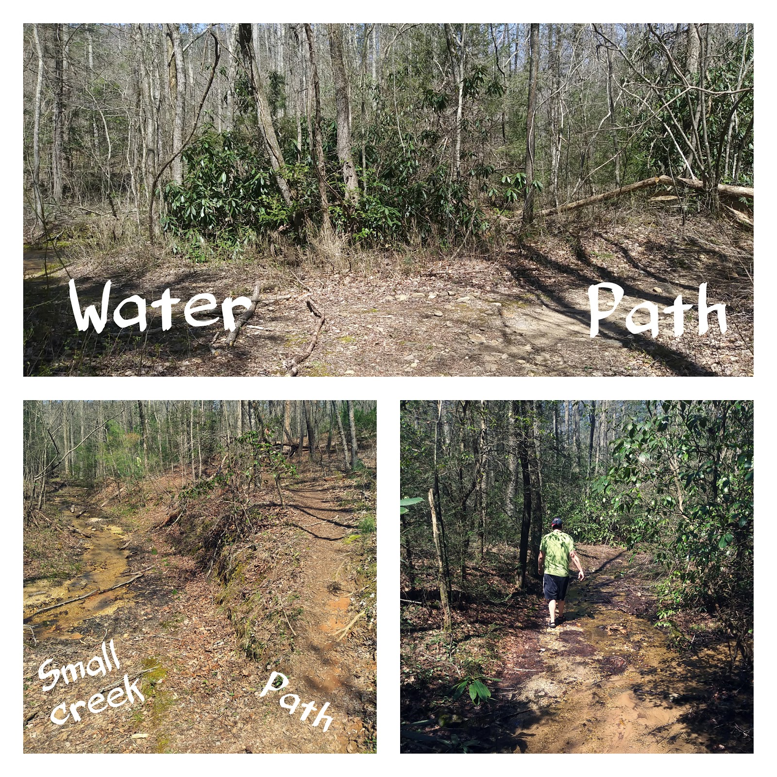
 At this point, you pretty much just meander down the path, which is flat and quite sandy, for a while. Parts of it reminded me of the scrub forests in Florida. Along this section, you will pass some places that appear to be creek crossings but always stay to the right and follow the path. I mention this and labeled it in the pictures because at times, there is a very shallow stream running along the path, but if there was a drought, the stream might dry up and appear to be a path. As long as you stay to the right after the first 2 foot crossings, you will be on the right track.

Eventually you will reach a densely wooded forest and the scenery will change. There are also camping spots in this area. One of the first things we noticed was a tree that had been struck by lightning and had a long scar along the trunk. The hallmarks of this area are large moss covered rocks on the left hand side and a incredibly large fallen tree. Climb over the middle of the tree and you will follow the path. After this point, the trail starts to incline slightly and eventually becomes the challenging "goat path".
 You'll know once you're on the goat path. The trail becomes extremely narrow, uphill, and frequently blocked by fallen trees. At this point, there are very small orange trail markers on the trees. It's imperative to look for these, otherwise you might end up straying from the goat path and actually making the hike more challenging than it already is. James got ahead of me for a while and missed a marker, which caused him to basically crawl on all fours up a really steep section. This part of the trail could be very dangerous, especially after wet weather. We experienced plenty of areas where the footing was extremely soft and gave way easily. There are also extremely slippery rocks you must climb over or around along parts of the path. Always use caution when grabbing trees for support, as some of the small trees in this area were unstable due to the wet ground and angle of growth along the path.

 Once we reached the lower levels of the falls, we stopped. I know the trail goes further because I've seen pictures on other sites from the upper areas. But again, the path was very wet, unstable, and James had already fallen once, so we decided to admire the falls from below. There are several smaller falls near the bottom that are very pretty as well, including some particularly nice "stair step" rocks. It's hard to really photograph or grasp the magnitude from where we were, but just knowing there was 600 feet of water/cliffs above me was awe inspiring.
The Cochrans Falls area is so rugged and natural; it felt completely different than places like Amicalola or Tallulah Gorge, where you have stairs or a viewing platform to use. While I am in favor of protecting natural areas obviously, I am happy there are some hidden gems still around. We did see a few other hikers on our way back, but we were alone during the entirety of the hike in. We were able to really take in the surroundings and focus on the peace and quiet. I also saw a snake basking in the sun and lots of butterflies. I love seeing critters and plants start to come out once spring rolls around.
Once we reached the lower levels of the falls, we stopped. I know the trail goes further because I've seen pictures on other sites from the upper areas. But again, the path was very wet, unstable, and James had already fallen once, so we decided to admire the falls from below. There are several smaller falls near the bottom that are very pretty as well, including some particularly nice "stair step" rocks. It's hard to really photograph or grasp the magnitude from where we were, but just knowing there was 600 feet of water/cliffs above me was awe inspiring.
The Cochrans Falls area is so rugged and natural; it felt completely different than places like Amicalola or Tallulah Gorge, where you have stairs or a viewing platform to use. While I am in favor of protecting natural areas obviously, I am happy there are some hidden gems still around. We did see a few other hikers on our way back, but we were alone during the entirety of the hike in. We were able to really take in the surroundings and focus on the peace and quiet. I also saw a snake basking in the sun and lots of butterflies. I love seeing critters and plants start to come out once spring rolls around.

As a bonus, once we reached the car, we actually met some descendants of the Cochran family. They parked near us and explained the the Cochran homestead was located in the woods just behind where we parked. They were looking for remnants (bricks, etc) from the homestead. They were very nice and explained the Cochrans were the first non-Native American settlers in the area. I'll admit, I know next to nothing about Georgia history so meeting these folks was interesting.
To wrap up, here are some nuts and bolts to help you are your way, should you choose to give Cochrans Falls a shot:
Length: 5 miles round trip; out and back; not a loop
Duration: about 3 hours, with frequent stops to take pictures and look around
Terrain: mostly flat and sandy, except the steep goat path
Difficulty: I'm going to say very difficult, because of the goat path climb. I would not recommend bringing dogs or children up the goat path. We did see people with dogs as we were descending, but I personally would not bring my dogs.
Gear tips:
Water friendly shoes are a must!
Durable/protective clothing (lots of climbing over/around trees and bushes on the goat path)
Trekking pokes or a good walking stick if desired
Emergency gear/first aid kit (I did have cell service during most of the hike but safety first!)
 After going to Dalton for about the 100th work related trip, I decided to see if I could find any trails to explore after work. While I've been to Dalton a lot, it tends to be for day trips usually or in winter when it's bitterly cold, but recently I was there overnight and had great weather. From what I've researched, there is a lot of recreation in the Dalton "area" but not so much close enough to drive to after work. For example, places like Fort Mountain, Cloudland Canyon, and the Cohutta wilderness area are in the same general region, but are too far away to drive at 5 pm once the work day is over.
  I was looking at Google maps and happened to notice a place called the "George W. Disney" trail that was only one exit away from my hotel. I began to research it online and saw it's only about 2 miles total in length (more on that later), yet has the reputation of being the "steepest short trail" in Georgia. I also learned George Disney was a Confederate soldier whose grave is along the trail. With it being so close by, what did I have to lose?
  I had no trouble finding the trailhead; it's literally 5 minutes off I-75 and shares a parking lot with a church (so no driving down remote, unpaved roads). There's also a very clear sign with an actual description of the trail (again stating how steep it is). So far, so good. I began going up the trail and soon noticed another trail diverting on the opposite side, but stayed to the trail on the right. The trail starts out relatively flat but then does begin to go up quickly. I saw beautiful, unique wildflowers all along the trail.
  There are several point where the trail splits off but they all reconnect eventually after a very short distance; not sure why these splits are in place but probably because numerous people have tried to do shortcuts and degraded the actual trail. Just keep going up, as there is really no other option. You'll soon see very large rocks ahead of you and this is where the trail disintegrates even further. You can climb onto the top of the rock formation but there is no defined way of doing this, from what I could tell. It seems many people have climbed up and around this rock face, as there are a lot of small, loose rocks to watch out for.
  There was only one other person on top of the rock face when I got up there and I would not recommend trying to climb up there if there were lots of people around. One wrong turn or slip could probably be fatal (not really exaggerating). The top of the rock face is gorgeous and the most clear angle faces west. The other sides are surrounded by trees, but still very pretty. I think in winter it would be even better. Sure, you can see/hear I-75 and other traffic below but that really didn't take away from the beauty.
  I saw a few other people on the trail, including kids, so it is reasonably easy and accessible. Regarding the "difficulty" of the trail, yes it is hard for a very short period of time. I tend to underrate rails and make them seem easier than they really are. I downloaded a GPS hiking app just before hiking this trail and according to it, I hiked 1.10 miles with 550 feet of ascent. So take from that what you will.
  One other thing to note, I didn't actually make it to the grave of George Disney. Oops. I thought it was unmarked/unknown and once I reached the rock formation, I stopped I also started talking with someone else near the rock formation and got distracted. I believe the grave is a little further down the south side of the rock formation. There is a trail continuing in this direction and I believe it goes for several more miles. More on that here