Here it is- our biggest adventure in California yet. We finally made it to Joshua Tree National Park! I will write a separate post about practical advice and tips for the actual trip, so that way I can focus on all the good stuff right now.
Since we were only planning to be in Joshua Tree for a day, I spent a lot of time researching and trying to figure out the best way to see the park. After reading a lot of articles and guides online, I found one I felt outline the park in a manageable, efficient way. Overall the Outdoor Blueprint website is just really great and I wish my blog was anywhere close to it!
We based our trip on this itinerary. I've bolded the different stops on the itinerary and I'll describe each section as we experienced it.

We started our day at the southern entrance to the park and stopped in at the Cottonwood Visitor Center. The ranger said visitors don't typically start here and we really didn't see any people until we got further along in the day, which was nice. We got a map and I was the navigator as James drove to our destinations. Overall, nothing was hard to find and there is plenty of signage throughout the park.
We accidentally skipped Cottonwood Springs, which is located near the visitor center, because I was distracted and excited about being in the park. We hopped right back in the car after talking to the ranger and I forgot to tell James to go to the Springs.
 We drove north on Pinto Basin Road for a while and stopped to take some pictures along the way. We then stopped at the Cholla Cactus Garden and walked around it. It is more like a Cholla forest with how many cactus plants there are. Cholla can get rather large also. There were a few taller than me (the ones I've seen in the past were short things). FYI, there is a first aid kit mounted to the fence at the Cholla garden, so I'm guessing some people have not followed the signs and tried to touch the cacti.
Shortly after leaving the Cholla, we started to see (what I thought were) really large rock formations so we pulled off at another area and started to climb around and explore them. Little did I know, we were about to see some really big rocks. The scenery starts to change as you drive north into the Mohave desert and it is really noticeable, particularly the actual Joshua Trees start to become prevalent!


We soon came upon the sign for Skull Rock. After seeing Skull Rock, I felt like every rock I looked at had some sort of facial features. Skull Rock is impressive but there were some really cool rock formations in the area behind it, so we spent a while climbing around back there. We saw a rock with a hole in the top of it, which showed blue sky behind it, as well as a sort of slot canyon. It was really fun climbing around on the rocks and I have a ton or respect for serious climbers, although rock climbing intimidates the hell out of me.

We then walked across the street to the Discovery Trail. It's a kid friendly nature trail that loops around some more rock formations and there are little signs along the way explaining different flora and fauna. This is a really great area to just stop and look around and take in the different scenery on the horizons. We also saw a roadrunner near the Discovery trail. I tried to take a picture of it but it darted away. Meep meep!
Next on the itinerary was a choice of either the Pine City Hike or Ryan Mountain Hike. It was close to noon time by the time we got to this point since we arrived at the park later than I hoped. I was worried about running out of time for the rest of the stops on our list. In retrospect, we probably could have fit another hike in, but I didn't want to be rushed. So we decided to not do either of these hikes and ate lunch instead. We just sat on the tailgate and used the hatch of the SUV for shade, which was quite pleasant.

After lunch we drove to Barker Dam and the parking lot was almost full, so I'm glad we got a parking space. Despite that, we didn't actually see too many people on the trail. The dam was really interesting and actually had quite a lot of water in it. It was just mucky rain water but the reflection of the rocks in it was perfectly clear. It was very pretty! The trail to and around the dam was very pleasant to walk along. Be sure to follow the arrow signs once you get to the dam and not just walk back to the parking lot. Around the side of the dam, there is a rock formation that has petroglyphs on it. Some of them are red or black, which is not their original state. People have drawn over them, which is vandalism. Regardless, it was neat to see.

The website I got the itinerary from said the Lost Horse Mine trail was the author's favorite hike, so I figured we really should not miss out on it. One thing to be aware of, the trail head is located on a dirt road. It was the smoothest dirt road I've ever driven on, so it shouldn't be an issue for any type of car. We had a SUV but sedans should be fine as well.
 There is a 4 mile or 6 mile option and we did the 4 mile. We had time to do 6 but James was getting pretty tired (he was one who drove to Joshua Tree after all, so I figured I'd give him a break). The Lost Horse trail isn't the most strenuous trail ever but it does have some inclines and there is absolutely no shade. It is a very pretty trail and the scenery all around is great. Lots of mountain views off in the distance with snow capped peaks. There are not really any large boulders or rock formations in this part of the park; the scenery is completely different but really beautiful. The mine itself is enclosed with a fence, I suspect probably due to vandalism, but the fence is easy to look through and you're able to get relatively close.
 We finished the hike around 3:30 pm and then drove to Keys View, which is conveniently located on the same road as the Lost Horse Mine hike. We had a little time to kill before sunset but I didn't want to get too far away from Keys view in the event parking became an issue as more people came to watch the sun set. So we chilled in the car for a while and James even napped briefly (I think). Keys View is a mountain overlook high above Palm Springs with views of the San Andreas fault, Salton Sea, Mount Gorgonio, and more. It was similar scenery to what we saw at Garnet Peak, but yet, totally different looking. The Salton Sea looks really cool at sunset, as it reflects the light and basically becomes a giant mirror. There is a formal viewing platform at Keys View but many people were sitting on picnic blankets on the side of the cliff. As the sun started to set, the temperature dropped significantly and the wind started gusting like crazy. I really wanted to see a good sunset but the wind was pretty unbearable. I tried to stick it out but I couldn't even hold my camera still due to the wind. I have a feeling the sunset got better after we left (it's always the best about 20 mins after the sun goes below the horizon) but oh well.

Leaving Keys view we drove toward the Joshua Tree exit and saw 2 coyotes crossing the road. They were smaller than the ones we have in Georgia. We also saw some rock climbers come down after their final evening climb. And then suddenly we were back in civilization. There was cell service, power lines, and street lights. Joshua Tree really felt like another world. We didn't stick around long enough to experience the darkness of the park but I could tell just being in the small towns bordering the park, it gets very very very dark.
Honestly, I feel like we experienced more in just one day than I had all year up until this point. I need to come to places like this more often. Away from people, away from civilization. I literally felt different while in the park.
Since we were only planning to be in Joshua Tree for a day, I spent a lot of time researching and trying to figure out the best way to see the park. After reading a lot of articles and guides online, I found one I felt outline the park in a manageable, efficient way. Overall the Outdoor Blueprint website is just really great and I wish my blog was anywhere close to it!
We based our trip on this itinerary. I've bolded the different stops on the itinerary and I'll describe each section as we experienced it.

We started our day at the southern entrance to the park and stopped in at the Cottonwood Visitor Center. The ranger said visitors don't typically start here and we really didn't see any people until we got further along in the day, which was nice. We got a map and I was the navigator as James drove to our destinations. Overall, nothing was hard to find and there is plenty of signage throughout the park.
We accidentally skipped Cottonwood Springs, which is located near the visitor center, because I was distracted and excited about being in the park. We hopped right back in the car after talking to the ranger and I forgot to tell James to go to the Springs.
 We drove north on Pinto Basin Road for a while and stopped to take some pictures along the way. We then stopped at the Cholla Cactus Garden and walked around it. It is more like a Cholla forest with how many cactus plants there are. Cholla can get rather large also. There were a few taller than me (the ones I've seen in the past were short things). FYI, there is a first aid kit mounted to the fence at the Cholla garden, so I'm guessing some people have not followed the signs and tried to touch the cacti.
 Shortly after leaving the Cholla, we started to see (what I thought were) really large rock formations so we pulled off at another area and started to climb around and explore them. Little did I know, we were about to see some really big rocks. The scenery starts to change as you drive north into the Mohave desert and it is really noticeable, particularly the actual Joshua Trees start to become prevalent!

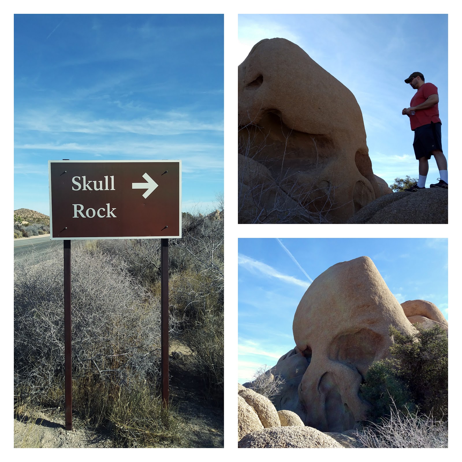
We soon came upon the sign for Skull Rock. After seeing Skull Rock, I felt like every rock I looked at had some sort of facial features. Skull Rock is impressive but there were some really cool rock formations in the area behind it, so we spent a while climbing around back there. We saw a rock with a hole in the top of it, which showed blue sky behind it, as well as a sort of slot canyon. It was really fun climbing around on the rocks and I have a ton or respect for serious climbers, although rock climbing intimidates the hell out of me.

We then walked across the street to the Discovery Trail. It's a kid friendly nature trail that loops around some more rock formations and there are little signs along the way explaining different flora and fauna. This is a really great area to just stop and look around and take in the different scenery on the horizons. We also saw a roadrunner near the Discovery trail. I tried to take a picture of it but it darted away. Meep meep!
Next on the itinerary was a choice of either the Pine City Hike or Ryan Mountain Hike. It was close to noon time by the time we got to this point since we arrived at the park later than I hoped. I was worried about running out of time for the rest of the stops on our list. In retrospect, we probably could have fit another hike in, but I didn't want to be rushed. So we decided to not do either of these hikes and ate lunch instead. We just sat on the tailgate and used the hatch of the SUV for shade, which was quite pleasant.

After lunch we drove to Barker Dam and the parking lot was almost full, so I'm glad we got a parking space. Despite that, we didn't actually see too many people on the trail. The dam was really interesting and actually had quite a lot of water in it. It was just mucky rain water but the reflection of the rocks in it was perfectly clear. It was very pretty! The trail to and around the dam was very pleasant to walk along. Be sure to follow the arrow signs once you get to the dam and not just walk back to the parking lot. Around the side of the dam, there is a rock formation that has petroglyphs on it. Some of them are red or black, which is not their original state. People have drawn over them, which is vandalism. Regardless, it was neat to see.

The website I got the itinerary from said the Lost Horse Mine trail was the author's favorite hike, so I figured we really should not miss out on it. One thing to be aware of, the trail head is located on a dirt road. It was the smoothest dirt road I've ever driven on, so it shouldn't be an issue for any type of car. We had a SUV but sedans should be fine as well.
 There is a 4 mile or 6 mile option and we did the 4 mile. We had time to do 6 but James was getting pretty tired (he was one who drove to Joshua Tree after all, so I figured I'd give him a break). The Lost Horse trail isn't the most strenuous trail ever but it does have some inclines and there is absolutely no shade. It is a very pretty trail and the scenery all around is great. Lots of mountain views off in the distance with snow capped peaks. There are not really any large boulders or rock formations in this part of the park; the scenery is completely different but really beautiful. The mine itself is enclosed with a fence, I suspect probably due to vandalism, but the fence is easy to look through and you're able to get relatively close.
  We finished the hike around 3:30 pm and then drove to Keys View, which is conveniently located on the same road as the Lost Horse Mine hike. We had a little time to kill before sunset but I didn't want to get too far away from Keys view in the event parking became an issue as more people came to watch the sun set. So we chilled in the car for a while and James even napped briefly (I think). Keys View is a mountain overlook high above Palm Springs with views of the San Andreas fault, Salton Sea, Mount Gorgonio, and more. It was similar scenery to what we saw at Garnet Peak, but yet, totally different looking. The Salton Sea looks really cool at sunset, as it reflects the light and basically becomes a giant mirror. There is a formal viewing platform at Keys View but many people were sitting on picnic blankets on the side of the cliff. As the sun started to set, the temperature dropped significantly and the wind started gusting like crazy. I really wanted to see a good sunset but the wind was pretty unbearable. I tried to stick it out but I couldn't even hold my camera still due to the wind. I have a feeling the sunset got better after we left (it's always the best about 20 mins after the sun goes below the horizon) but oh well.
Leaving Keys view we drove toward the Joshua Tree exit and saw 2 coyotes crossing the road. They were smaller than the ones we have in Georgia. We also saw some rock climbers come down after their final evening climb. And then suddenly we were back in civilization. There was cell service, power lines, and street lights. Joshua Tree really felt like another world. We didn't stick around long enough to experience the darkness of the park but I could tell just being in the small towns bordering the park, it gets very very very dark.
Honestly, I feel like we experienced more in just one day than I had all year up until this point. I need to come to places like this more often. Away from people, away from civilization. I literally felt different while in the park.